


المدونة
Fakk al Asad Passage: Hydrographic Reality Behind the Hormuz Claims
ملخص تنفيذي
Key Takeaways for Logistics Leaders
- Natural Topography, Not Artificial Dredging: The viral 490m-wide passage is actually Fakk al Asad—a long-charted natural deep-water gap with no satellite evidence of engineering excavation.
- Sovereignty and Legal Realities: The Musandam Peninsula falls under strict Omani jurisdiction; any unilateral engineering or major coastal modification requires formal state authorization under UNCLOS.
- Operational and Safety Constraints: Navigating a VLCC through narrow coastal gaps introduces severe grounding, collision, and insurance warranty risks that override speculative shortcut claims.
- Tactical Radar Fallacy: Supertankers cannot achieve stealth by hugging coastal cliffs; their physical dimensions and mandatory AIS tracking keep them fully visible to regional and space-based surveillance.
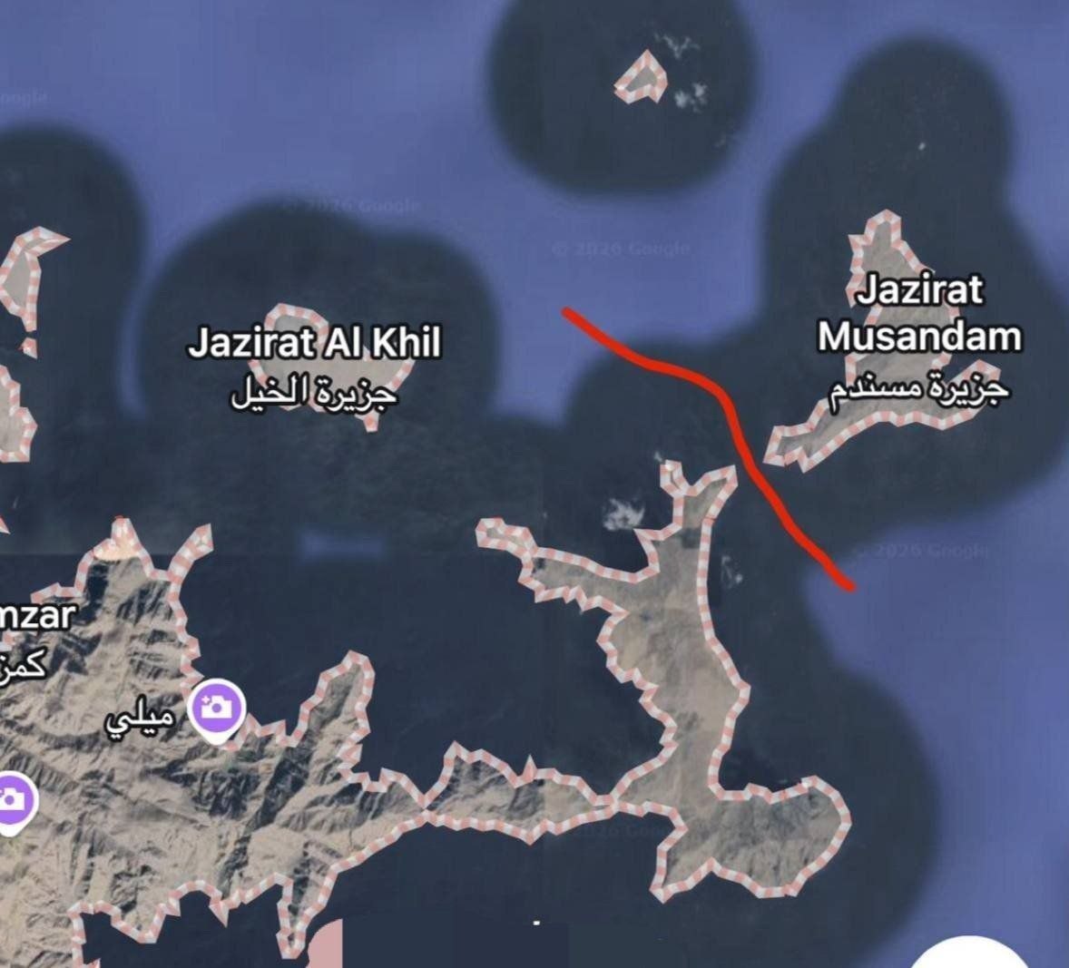
Satellite imagery circulating in late August 2026 triggered a rapid wave of claims that a previously unused deep-water corridor had been opened on the southern approaches to the Strait of Hormuz near the Musandam Peninsula. Reports described a passage roughly 490 meters wide and about 30 meters deep, allegedly sufficient for fully laden Very Large Crude Carriers and positioned to alter transit patterns. For logistics planners, charterers, and supply-chain risk teams, the assertion raised immediate questions about routing options, under-keel clearance, chart reliability, and insurance implications.
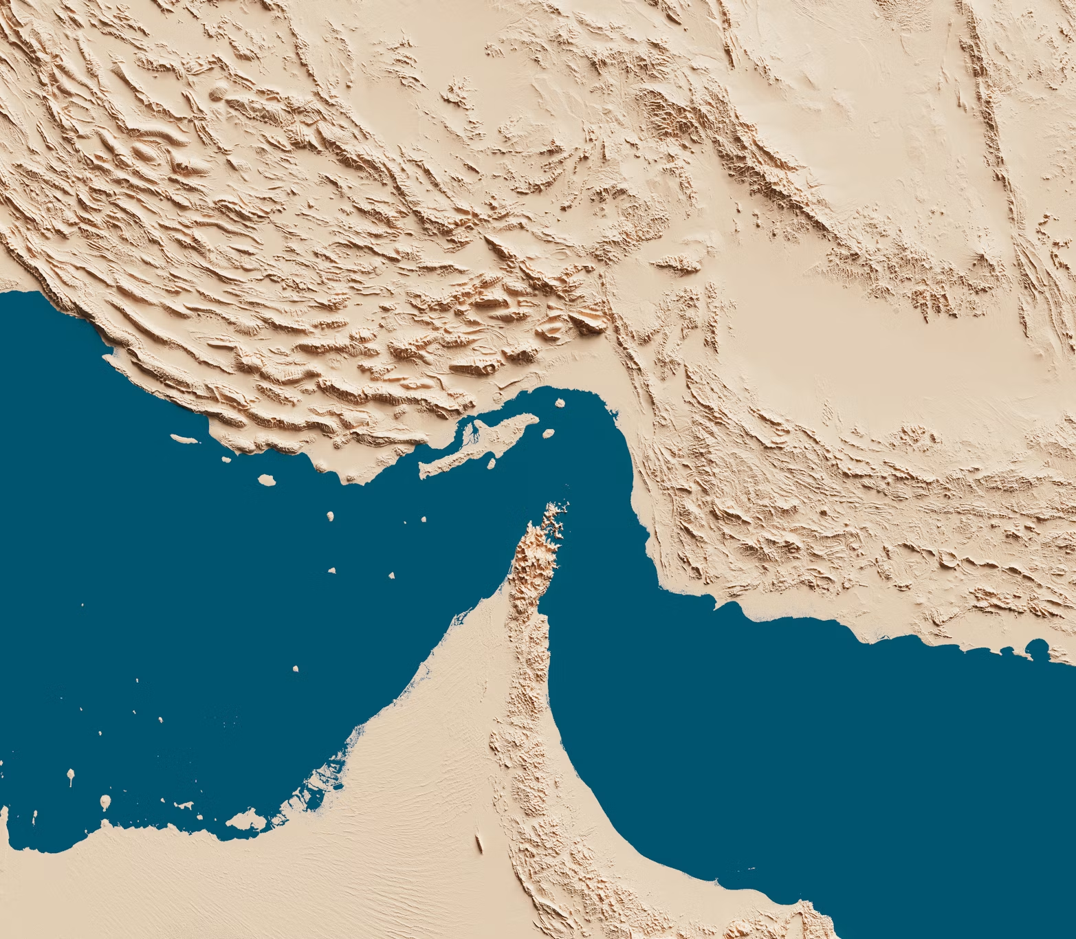
Strait of Hormuz
The viral claims originated in late August 2026 across fringe political commentary channels—including US-based political accounts and sensationalized regional social media outlets—alleging that the US military had conducted covert dredging or mountain-carving operations to bypass regional radar coverage. While these reports reframed routine satellite imagery as a newly engineered bypass, hydrographic evidence confirms the feature is entirely natural.
✔Circulated Late-August 2026 • Social Media / Telegram
“BREAKING: US Navy hydrographic units reportedly completed covert channel excavation near Musandam Peninsula (Strait of Hormuz). A new 490m-wide, 30m-deep passage bypasses radar grid. Fully laden supertankers now executing discrete transits…”
Hydrographic records and standard sailing directions resolve the matter without ambiguity. The feature identified in the imagery is the long-charted natural passage known as Fakk al Asad (also referred to as Bab Musandam). It is a deep-water strait approximately 0.2 nautical mile wide that separates Ras al Bab from Jazirat Musandam. Historical surveys already recorded it as clear of dangers, with depths measured in fathoms that comfortably exceed modern VLCC requirements. Power vessels with local knowledge have used the passage for generations. Recent satellite analysis shows no dredging signatures, no spoil banks, and no engineering disturbance consistent with a newly created channel. The geometry visible today matches the charted natural configuration.
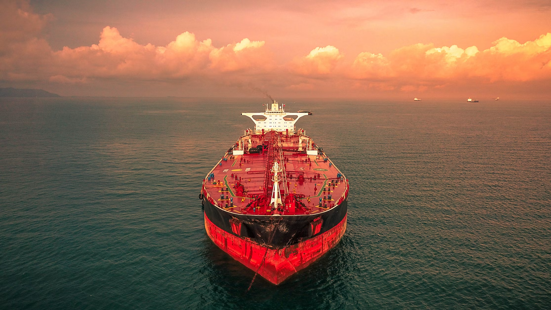
VLCC
This distinction matters for commercial operators. Misreading a natural coastal feature as a constructed corridor can distort risk models, freight calculations, and contingency planning. The following analysis examines the claim through the lenses of bathymetry, vessel performance, traffic-separation rules, and supply-chain economics.
Hydrographic Reality versus Viral Interpretation
The Musandam Peninsula forms the southern boundary of the narrowest section of the Strait of Hormuz. Its limestone cliffs and fjord-like inlets create a complex shoreline. Standard nautical publications describe Fakk al Asad as a deep-water passage roughly 370 meters wide at its narrowest, free of reported dangers in the fairway, and subject to strong tidal currents that demand precise helm control. Depths in the vicinity have long been recorded at levels well above the 27–30 meter design thresholds sometimes cited for modern deep-draft navigation channels.
By comparison, a purpose-built VLCC corridor would require deliberate design parameters. Industry guidelines for deep-draft channels typically call for bottom widths several times the design vessel’s beam, side slopes suited to the local geology, and continuous under-keel clearance margins that account for squat, heel, and wave response. A fully laden VLCC of approximately 300,000 DWT commonly draws 20–22 meters. Safe navigation in restricted waters generally requires additional clearance of 10–15 percent of draft, plus allowances for dynamic effects. Achieving a reliable 30-meter navigable depth across a multi-hundred-meter width would leave clear evidence of excavation, disposal sites, and survey updates. None of those signatures appear in the imagery that fueled the claim.
Charted depths in the main traffic lanes of the Strait itself reach 70–80 meters in places, providing ample absolute clearance for commercial tankers under normal conditions. The limiting factors have always been the lateral constraints of the traffic lanes, traffic density, and the need to remain within designated routes rather than absolute water depth.
Beyond hydrographic dimensions, claims of covert engineering or unilateral channel clearance by foreign forces ignore the foundational legal reality of the Strait. The Musandam Peninsula and its adjacent territorial waters fall strictly under the sovereign jurisdiction of the Sultanate of Oman.
Under the United Nations Convention on the Law of the Sea (UNCLOS) and customary international law, any major dredging, infrastructure modification, or physical altering of coastal seabed features within territorial waters requires explicit authorization, environmental permits, and formal diplomatic notification from Muscat. No unilateral foreign military or commercial entity could execute a heavy engineering project in Omani waters without immediate state oversight and international hydrographic registry updates.
Traffic Separation Schemes and Operational Constraints
The International Maritime Organization maintains a Traffic Separation Scheme in the Strait of Hormuz consisting of inbound and outbound lanes, each approximately two nautical miles wide, separated by a comparable buffer zone. The scheme was established to manage opposing traffic flows in a confined waterway and is reflected on official charts. Large commercial vessels are expected to follow the appropriate lane under SOLAS Chapter V.
The geometry places significant portions of the scheme within Omani territorial waters along the Musandam side. An inshore traffic zone closer to the coast has historically been restricted to smaller vessels. Operators planning transit must therefore reconcile vessel draft, length overall (typically 300–340 meters for a VLCC), maneuvering characteristics, and the requirement to remain within the designated lanes. Departing from the scheme to explore a narrow coastal passage introduces collision risk, grounding risk near the shoreline, and potential complications with coastal-state reporting requirements.
For commercial risk teams, the practical question is not whether a narrow natural gap exists, but whether that gap offers a scalable, charted, and insurer-accepted alternative for high-value bulk cargo. The answer, based on published sailing directions and standard routeing measures, is no. The passage is too constrained for routine two-way traffic of large tankers and has never been presented as a substitute for the main TSS.
A core assertion in circulating narratives is that commercial vessels utilize this coastal passage to slip under regional radar coverage or bypass military monitoring zones. From a naval surveillance and radar cross-section (RCS) perspective, this assumption is fundamentally flawed.
A fully laden Very Large Crude Carrier (VLCC) stands up to 30 meters above the waterline with a length exceeding three football fields. Hugging high-altitude coastal cliffs like those of Musandam does not grant radar shadow; rather, it increases coastal clutter while remaining fully visible to modern coastal land-based radars, airborne surveillance (AEW&C), satellite synthetic aperture radar (SAR), and mandatory Class-A Automatic Identification System (AIS) tracking. Maneuvering a supertanker through narrow coastal gaps actually exposes the vessel to elevated navigational hazard without offering any tactical stealth.
Vessel Performance and Under-Keel Clearance in Practice
Fully laden VLCCs operate with limited residual clearance even in relatively deep water once squat, trim, and wave-induced motions are considered. In open or semi-confined waters, masters and pilots manage under-keel clearance continuously, integrating real-time depth data, tidal predictions, and speed-dependent squat models. In a passage only a few hundred meters wide, the margin for error shrinks dramatically. Any temporary reduction in depth from sedimentation, a misjudged current, or a steering failure leaves little room to recover.
Historical use of Fakk al Asad by vessels with local knowledge does not translate into a commercial recommendation for modern deep-draft fleets. Charter-party clauses, P&I club guidance, and classification society standards emphasize adherence to IMO routeing measures and up-to-date electronic charts. Introducing an uncharted or misinterpreted coastal shortcut would trigger additional due-diligence requirements, possible warranty issues, and higher war-risk or navigational-risk premiums.
Economic and Logistical Implications for Cross-Border Trade
Claims of a newly available corridor can influence short-term freight rates, bunker planning, and inventory strategies. When operators believe an alternative deep-water route has opened, they may adjust expected transit times or insurance loadings. Once the claim is tested against official charts and satellite ground-truth, those adjustments reverse. The resulting volatility adds friction costs to the supply chain.
For Gulf-region traders moving bulk commodities, refined products, or project cargo, the more reliable planning tools remain:
- Continuous monitoring of official NAVAREA warnings and coastal-state notices
- Verification of the active Traffic Separation Scheme status
- Calculation of end-to-end voyage costs that incorporate demurrage exposure, bunker consumption, and insurance
- Contingency routing via established overland or pipeline alternatives where commercially viable
Tools that support accurate HS-code classification, duty estimation, and multimodal cost modeling help convert hydrographic uncertainty into quantifiable risk. Platforms that aggregate real-time logistics data allow teams to test routing scenarios against actual vessel performance rather than viral imagery.
Distinguishing Natural Features from Conceptual Engineering Proposals
Separate from the specific claim of a newly dredged coastal corridor, longer-term conceptual studies have examined the theoretical possibility of cutting an artificial waterway across the base of the Musandam Peninsula. Such proposals face steep topographic obstacles, including ridges rising hundreds of meters above sea level, fractured limestone geology, and the enormous volume of material that would need to be removed. Feasibility sketches that appear in open sources typically specify design drafts of 24–27 meters, bottom widths of several hundred meters, and extensive lock or slope systems. The capital cost, construction timeline, and environmental footprint place these concepts far outside near-term commercial planning horizons.
For day-to-day logistics decisions, the distinction is critical. A natural coastal gap that has existed for centuries does not become a strategic shipping artery simply because satellite imagery is re-circulated with new captions. Conversely, a multi-decade engineering mega-project remains speculative until detailed geotechnical surveys, environmental impact assessments, and financing commitments materialize.
Practical Steps for Commercial Operators
- Cross-check any circulating imagery against the latest official electronic navigational charts and sailing directions.
- Confirm the status of the IMO Traffic Separation Scheme and any temporary routeing measures issued by coastal authorities.
- Recalculate under-keel clearance for the specific vessel and loading condition rather than relying on headline depth figures.
- Update voyage risk assessments and notify insurers of any material change in intended routing.
- Model alternative cost structures that include possible delays, additional pilotage, or diversion via established Gulf ports.
Accurate hydrographic knowledge reduces the noise that viral claims introduce into freight markets. Teams that maintain disciplined chart management and scenario modeling retain pricing power even when public discussion is dominated by unverified imagery.
Hafeet Rail Guide: How to Cut GCC Freight Costs by 40%
Closing Perspective for Supply-Chain Decision Makers
The feature highlighted in recent reports is a natural passage that has been documented in nautical publications for generations. It does not represent a newly engineered deep-water corridor capable of absorbing significant commercial traffic. For B2B operators moving cargo through the Gulf, the operational priority remains adherence to established routeing measures, continuous verification of charted depths, and rigorous under-keel clearance management.
Reliable logistics planning rests on primary hydrographic sources and vessel-performance data rather than secondary interpretations of satellite frames. When those sources are consulted, the claim of a 490-meter, 30-meter artificial channel dissolves into the geography that has always existed.
For traders seeking structured tools that support accurate cost modeling, compliance documentation, and multimodal scenario analysis across Gulf routes, the operational suite available at Platform.Tendify.Net provides practical support without replacing professional hydrographic advice. Related operational guidance on port cost control and multimodal routing can be found in the analyses of demurrage exposure in GCC ports and the broader Gulf logistics cost framework published on the Tendify blog.

